
James Wagstaff
Chief Revenue Officer
Raptor Maps

We are proud of our work with ENGIE, who is using our platform across their global solar fleet, spanning 90 solar sites and over 6.5 GW.
Since ENGIE New Ventures (ENV) invested in the startup in 2022, Raptor Maps’ solutions have been widely deployed across ENGIE’s solar assets worldwide, supporting operations teams in improving efficiency, reliability, and decision-making at scale.
For the second time, Raptor Maps will be present at VivaTech (June 17–20, 2026) on the ENGIE booth. On this occasion, we spoke with James Wagstaff, Chief Revenue Officer at Raptor Maps, to learn more about the company, its collaboration with ENGIE, and how AI is already delivering tangible impact for the solar industry.
Our company builds the operating system for the solar industry. Through AI, robotics, and advanced digital-twin software, our mission is to digitize and analyze the world’s solar information to increase the efficiency, reliability, and financial performance of solar assets. In my role, I am responsible for our commercial activities. I ensure that the market understands our solutions and that our customers are realizing exceptional returns from their work with Raptor Maps.
We are reversing the rising trend of solar underperformance by using AI-powered robotics and analytics to automate manual work. With robotics and AI, Raptor Maps is also helping to de-risk assets and provide safer working conditions by identifying critical hazards – like substation anomalies or faulty wiring – before they lead to outages or fires.
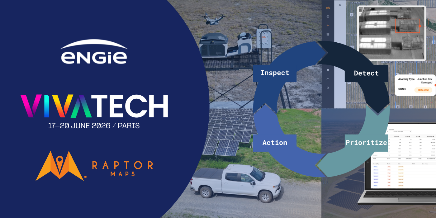
While there are a number of providers of drone-based inspections in the solar industry, Raptor Maps stands apart due to our reliability, precision, speed, and workflow integrations. Our autonomous drone solution, Sentry, is operational on over 15 GW of solar assets around the world with some of the biggest utilities, IPPs, and operators – a testament to the deep, solar-specific technical expertise our team brings to creating purpose-built solutions for solar asset management and O&M.
Beyond our robotic expertise, with over 373 GW of data analyzed across 30+ inspection types spanning aerial thermography, high voltage equipment, civil & environmental conditions, and more, Raptor Maps has unmatched operational knowledge, enabling us to uniquely understand industry challenges, and design highly tailored solutions to them.
We are proud of our work with ENGIE, who is using our platform across their global solar fleet, spanning 90 solar sites and over 6.5 GW. This includes work supporting ENGIE's largest solar site in the world: Assu Sol. ENGIE uses Raptor Maps technology to bring consistency to solar data across a global portfolio, enabling the team to make confident management decisions and optimize energy production and reliability.
ENGIE’s team of experts has also been an especially valuable partner for Raptor Maps. Over the years, our teams have worked closely together to develop technical solutions, engage in R&D work, and pilot numerous initiatives.
We will be showcasing our global solar research along with videos of our Sentry autonomous drone solution, which is introducing an operational paradigm shift in the solar industry. Sentry is changing the unit economics underlying how often sites can be inspected. Since we have deployed Sentry, data indicate that sites with the technology are gathering performance data almost 12x as frequently as sites without it. Additionally, teams are leveraging Sentry to gather intelligence on an array of additional components on a solar farm, including back-of-panel wiring, tracker components, civil and environmental conditions, and high voltage equipment. Collectively, this increase in both data frequency and robustness has helped teams with Sentry to increase asset performance – the average power loss across our data set in 2025 was 5.08% for all sites, but on sites with sentry, it was just 3%
At Raptor Maps, we use AI as the connective tissue between robotics, advanced analytics, and humans on site each day. Our platform lives at the intersection of these three pillars:
As more data systems on solar farms are able to speak to one another with the help of AI, we see an ecosystem of robotics enabling human decision making and increasing asset uptime.
An example is that we have permanently stationed drones connected to a SCADA system, which sends an alert when a block is underperforming. The drone, being connected to this SCADA system, is then immediately triggered to fly the block for root cause analysis without requiring a human to mobilize. A report with comprehensive analysis of the block is in the performance engineer’s hand within two hours of the alarm, and a site team is sent to remediate issues that have been geo-located to precise parts of the block.
With robotics and AI, Raptor Maps believes the solar industry can operate with the complexity, precision, and minimized latency of space flight.